Frontlist | BBC Takes Distorting India's Map To New Low; Excludes J&K-Ladakh Entirely, Corrects Badly
Frontlist | BBC Takes Distorting India's Map To New Low; Excludes J&K-Ladakh Entirely, Corrects Badly
on Jan 20, 2021
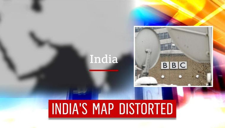
While foreign media houses often distort India's map, in a shocking and completely unprecedented case, the BBC has now left out the union territories of Jammu & Kashmir and Ladakh from India's map entirely, in a video for a story on the US elections. In the video, which has since been corrected, the territories of the newly formed UTs (comprising the erstwhile state of J&K) were left out from India's map altogether while the rest of India was highlighted in red.
The video sparked outrage on the Internet following which complaints were made to BBC demanding the appropriate areas to be represented accurately on the map. BBC's video at the time of publishing this story was updated, though the colour scheme rather glosses over whether J&K and Ladakh have been restored to their rightful place in India's map. The criminally botched map will not be reproduced here, the 'corrected one' is below, with borders not entirely clear.
This form of callous distortion of India's map assumes slightly more significance given that it comes from the UK's official broadcaster. The retreating British and their similarly callous map-drawers are widely considered responsible for the deaths of thousands during the time of partition. Global media misrepresenting India is also part of the reason why India needs homegrown news & media organisations with a worldwide reach and impact, something that Republic Media Network's Editor-in-Chief Arnab Goswami spoke about recently when he addressed an event of Indian diaspora.
On numerous occasions in the past, foreign media and tech giants have distorted India's map by leaving out PoK (Pakistan Occupied Kashmir), Leh, Ladakh, and other bordering areas. Recently, the World Health Organization's (WHO) official website displayed Jammu & Kashmir and Ladakh as separate countries on a world map while the rest of India was grouped as one - evident from the different colours that were used. In the map, India was coloured in blue but Jammu & Kashmir was coloured in grey and India's territory that is occupied by China under the name of 'Aksai Chin' in Ladakh is in a blue-grey strip.
Before that, on October 18, 2020, microblogging platform Twitter had once again come under the fire for displaying Ladakh as a part of the 'People's Republic of China'. National Security Analyst Nitin Gokhale who was live on Twitter near Leh airport, noticed that his location was displaying as 'Jammu and Kashmir, People's Republic of China'. This anomaly was raised by Observer Research Foundation (ORF) chairman Kanchan Gupta to Twitter India, stating that it was not an 'isolated incident', but that several netizens who were logging online faced the same issue. Twitter was asked for an explanation by the Parliamentary Committee on IT and issued an apology, going on to correct its maps. Misrepresentation of India's map or national symbols is illegal.
Source: https://www.republicworld.com/india-news/general-news/bbc-takes-distorting-indias-map-to-new-low-excludes-j-and-k-ladakh-entirely-corrects-badly.html

.jpg)


.jpg)
.png)
.jpg)
.jpg)
.jpg)
.jpg)
.jpg)


Sorry! No comment found for this post.